Everyone’s experiences are different, even when walking side by side. We decided to let you hear about our 300km walk across England from each of our perspectives, I hope you enjoy the contrasts.
Day One – St Bees to Enerdale
Art’s impressions
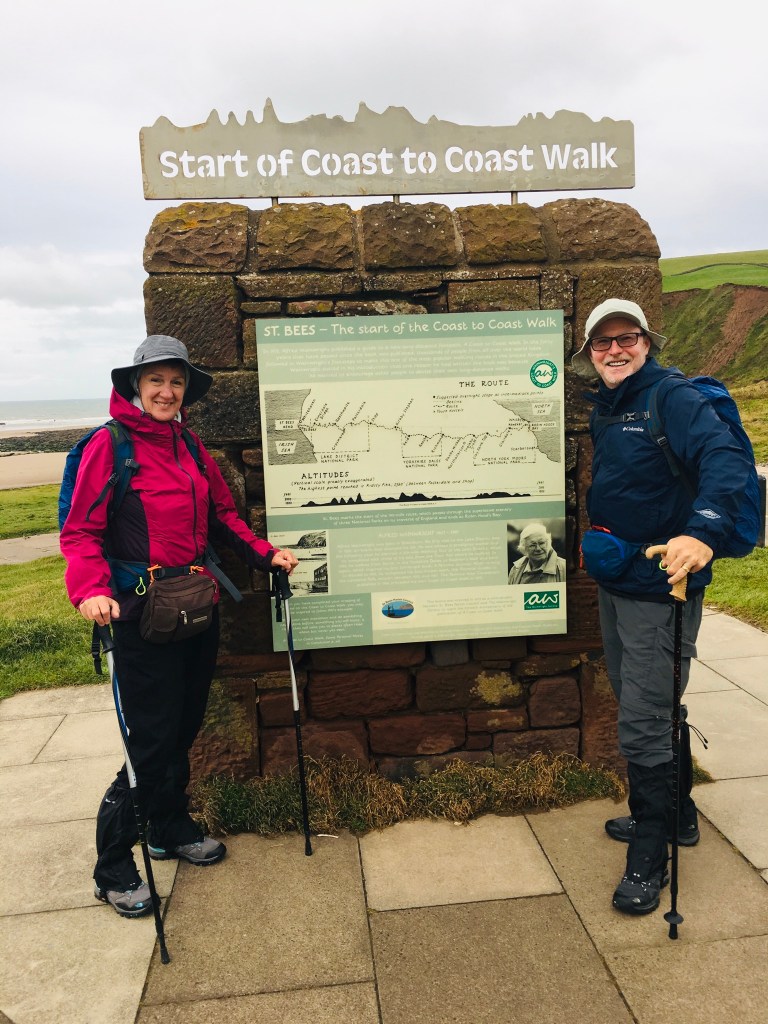
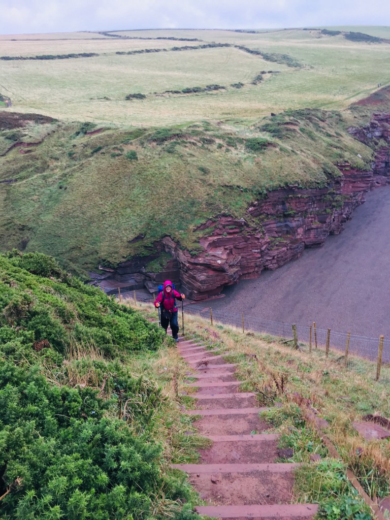
After dipping our toe in the Irish Sea, we grabbed our rock from the beach which, like us, was destined for the North Sea on the east coast at St Robins Bay. We climbed St Bees Head which rises 100 meters from the ocean and stretches for miles north toward Whitehaven. The trail followed the edges of the cliffs offering spectacular views, unfortunately impaired by first drizzle and then all out rain. After following the cliffs for 2 miles we veered inland and started the trek in the direction of the lake country. Thanks to the book we bought, Steadman’s Coast to Coast, we were able to navigate the various public footpaths in the direction of Ennerdale, our destination for the first night. We crossed paths with various groups over and over during the day, offering us some comfort as we became familiar with the map books. This day was 14 miles in total (22.5 kms) but the iPhone app said 28 kms, so our map navigation clearly needs improvement.
Heidi’s impressions
As I lie here on my bed in our Inn at 6:00 pm, the only thing keeping me awake is the excruciating pain in my thumb, feet, knees, hips and back! This Coast to Coast Walk (C2C) may be a bit of a challenge haha! The day started out beautifully, though with a slight rain, in St Bees as we dipped our boots in the Irish Sea and collected a rock from the beach to carry with us and deposit at the end of our journey in Robin Hoods Bay on the east coast. This is a tradition amongst C2C walkers of which there are approx. 10,000 each year. This had me envisioning truckloads of rocks regularly being sent back to St Bees lest the beaches be depleted!

We walked north along the high headlands, enjoying spectacular views (well Art did. I suffer from almost debilitating fear of heights that is only manageable by looking down at my feet). The walking was relatively easy and we enjoyed ourselves as terrain changed to peaceful fields, dotted with sheep and cows, and progressed to rolling hills.
Unfortunately, the rain progressed also: but the driving torrential rains had us still chuckling that we were still having fun on our grand adventure. Until we weren’t. After about 7 hours (and 14 miles) our feet as well as everything else was soaked and joints and bones were aching. We arrived at our prearranged accommodations at the Inn, stripped off and covered every surface with our sodden gear, had a groaningly good hot bath and filling dinner and that’s it, I am toast!


Day Two – Enerdale to Rosthwaite
Art’s impressions
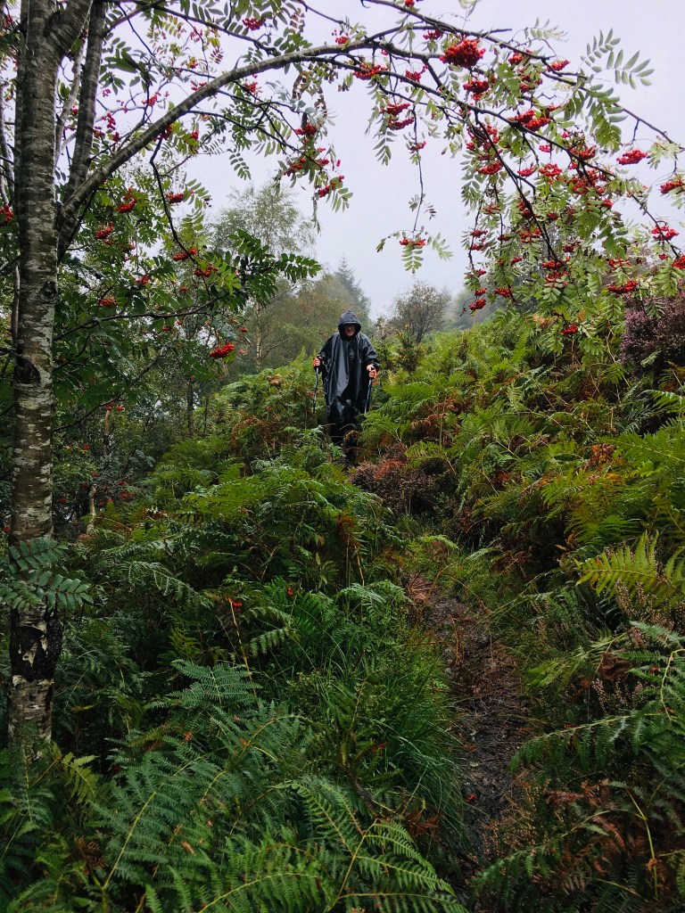
Hopes of a clear day faded as soon as we looked out the window in the morning. We dressed in ALL our rain gear including our gators and poncho to prepare for another wet day. We determined that because of the amount of rain we needed to take an alternate route down the south side of the Ennerdale waters to avoid the torrential rivers on that side. We found the ponchos to be lifesavers until we made the monumental accent of the blackbeck tarn, which was shrouded in fog as we started our climb.

This climb made the grouse grind and the Chief seem like a walk in the park. Straight uphill over 1100 feet crossing rushing streams 3 times on the way up. At one point an elderly woman slipped and fell cracking her head on one of the many stones jutting from the hillside and bleeding profusely from the eyebrow. Heidi was a trouper. Never looking back down the trail, which was more a creek that a trail with all the rain we were getting. And to add to the challenge the wind was whipping UP the hill which was causing our ponchos to flip up blocking our view of the upcoming slippery steps. I finally got fed up and pulled it off and benefited greatly with increased vision. Coming down the other side of the tarn wasn’t much easier because if the limited visibility and torrents cascading down the trail. We were never so happy to see the front door of a hotel as that day.

Heidi’s Impressions
As I lie here on my bed in the Inn, I can hardly believe that I survived this day. It was raining when we woke up and it did not cease all day. What this means is that every part of the path that says “boggy” had become a quagmire with the potential to sink you to your knees and every “beck” had become a raging white-water river that we had to cross.

There were stretches for hours of extremely steep rocky climbing that petrified me. We actually witnessed someone from the group ahead of us unbalance and fall backwards, and in my worst nightmare, rolled down the hill and hit her head on a rock. We all rushed to her aid but her companions waved us on and we all filed by and saw her sitting there dazed and bleeding from her head and facial wounds. We saw her group physically assisting her to continue climbing but we assumed they eventually turned back to a point where mountain rescue could reach them as we no longer saw them behind us.

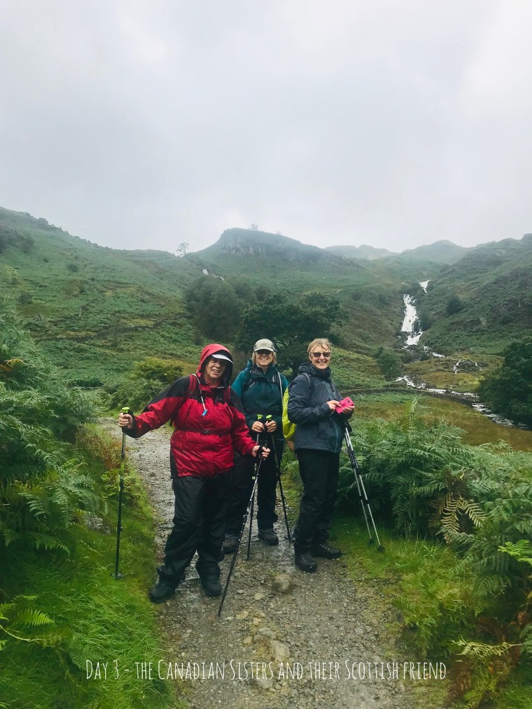
The path was extremely difficult to follow despite maps and GPS, made more so by mists which greatly, reduced our visibility, and to top it off, for all this effort, the promised views were completely shrouded. We had a few charming moments: walking the length of a gorgeous lake; reuniting with 2 Canadian sisters with whom we walked for the rest of the day; having our lunch and a cup of tea with numerous other walkers at Black Sails, the most remote hostel in England (if not the world!); coming down off the mountain and having the mists clear momentarily to glimpse a valley floor of unreal green dotted with small white dots (which we know to be sheep). Would I do it again? Not on your life!

Day Three Rosthwaite to Grasmere
Art’s impressions
Day three was forecast to be awful and to make matters worse, both our walking friends, the Canadian sister, told Heidi she shouldn’t walk this route due to the high “scramble” needed to get up one face. The meaning of scramble was a granite face that was very sheer and had loose bits to make things trickier. Even in dry weather this route is bad for people afraid of heights, but on this day would have frozen Heidi because of the wind and rain. So Heidi caught a ride with the Canadian sisters and I walked the route.
If we haven’t already mentioned the routes are not well marked and Heidi’s last words to me before kissing me on my way was “read the maps and don’t take chances”. “Well of course I will honey” was my reply and off I went. The first cross roads I hit I saw a group veering left uphill so I followed. As I passed them I confirmed, “Off to Gracemere are we?” to which they replied, “yes sir governor “. I began striding uphill feeing great as it wasn’t raining and I had free rein to go as fast as I wanted. It was a straight uphill descent on stairs all the way to the top where I had magnificent views. Then I checked the GPS coordinates only to discover I was WAY off course. I had taken a wrong turn and had climbed 475 meters (1500 feet) the wrong way. I had to hoof it back down the way I came and got on the correct route but felt frantic as I was an hour behind most other C2C walkers.

I began turning on the afterburners to try and catch up, and of course forgot my promise to be careful. I was making terrific time and finally saw a couple of groups up ahead about a KM uphill. It had started to really rain hard and the streams were flowing like rivers making crossing them tricky. In my haste crossing one I was going too fast and slipped on some lichen on the rock and tumbled backwards into the stream, catching myself before plunging 8-10 feet down to the pool below. My leg was bent back in a precarious position on my bad knee side but my adrenaline kicked in and I pushed myself backwards up and out of the stream onto my back. I was completely soaked from the waist down but it didn’t matter because I was already soaked from the waist up by the rain so I was totally soaked. I scared me just enough to slow me down and take it a little more easy.

I finally caught up with the group ahead and it turned out to be a group of three German girls we had walked with over the previous days and two other couples from Nottingham (I named the Robin Hood and his Merry men & women). They had made it to the second ridge and had decided to veer right and down into the valley, which was NOT the correct way, thank god for compasses and GPS, that pointed us up the face of another ridge to the “scramble” mentioned earlier. By now the wind was howling at gale force and it was raining sideways, thankfully uphill and at our backs.
We all made it to the top of this scramble but I was sure happy Heidi wasn’t there. It was 300 meters straight up with narrow footpaths up to the sheer face and we were on hands and knees because the rain was cascading down the face. Once we reached the ridge we found ourselves in a boggy meadow that was nearly impossible to cross without going knee deep in the bog. If it weren’t for the cairns (pile of rocks like a pyramid) to show our way there was no discernible pathway. The only lucky thing was we had no mist so we could see 50-75 meters ahead to the next cairn. We crossed the 400-500 meters in about 30-45 minutes.
Luckily once through the meadow it was downhill after that. It wasn’t without incident as we came across a women in distress on the way down. She was sitting next to a swollen stream that she was too afraid to cross and she was shaking like a leaf. Our group of eight did our best to console her while her useless husband crossed the stream and started down. I went across a tricky rock step and helped everyone across the stream by literally yanking then across into the bank. One of the Germans refused my help and she ended up in the stream almost getting swept downstream, I grabbed her by the scruff of her neck and dragged her out. Except for more rain and wind we finished the descent without anyone getting hurt. Heidi awaited me when I arrived with a big hug, (after I changed out of the west clothes) a warm drink and a sympathy for my ordeal.
Heidi’s Impressions
At dinner last night with the Canadian sisters (Claire and Deirdre) who had done the C2C last year, they told us of some upcoming tricky parts that was making them decide to forego this leg and drive to Grasmere. The preceding days of rain were expected to swell some mountain streams into dangerous waterfalls and there were also some very steep peaks to navigate. The bartender, a local, said wryly “I wouldn’t do it”. Also knowing of my fear of heights they invited me to join them.

Art was keen to go and so he set off in the morning with the reasonable expectation that he would join with other walkers along the way, and we would meet in Grasmere. I set off with the Canadian sisters and their friend from Scotland who came down in her car walk with them.
We drove the 14 miles or so to Grasmere and walked that portion of the C2C backwards as far as we could. It was lovely going initially, only a slight drizzle as we walked out of town past the sheep and rose out of the fields onto a rocky path heading steadily up to the summit of Easedale Tarn. However, as time went on the rain came down in torrents and the wind steadily increased. When the locals that we met coming down told how nasty it was at the top (and these locals will usually brave anything in any weather), I was very glad that I had not undertaken the crossing.
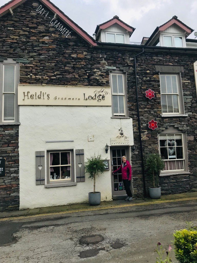
Day 4 Rest Day Grasmere
Grasmere is a very charming town: home and burial place of William Wordsworth (this area inspired much of his poetry); many shops, restaurants and cafes but sadly no real pubs. We stayed here for 2 nights and enjoyed a rest day here. This meant though that the friends that we had made, moved on without us. Will just have to make more!

Day 5 (Grasmere to Glenridding)
Art’s Impressions
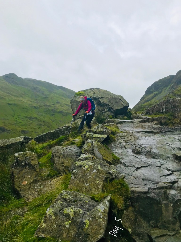
We began the day with a spring in our step due to our rest day and the good weather we awoke to. We strolled out of Grasmere past beautiful stone homes and brilliant green fields full of sheet. I swear there are more sheep than people in England. Once we began the initial ascent up a stone path, we stopped to look back and capture the beauty of this little town and have a water break.

We pressed onward up the path and after crossing a stream we looked up at the view of our path to the top, 1500 feet up a steep grassy path. The good news was it was in the sun. As we moved upwards we remarked on how we were beginning to feel better and stronger from the “trail training” over the previous three days. We stopped a few times to look back at the sweeping view below put pressed on to our intended stopping point at the top of our emerald green trail. We were both elated when we reached the top and after taking on water, Heidi reached for her phone to capture the view and realized it wasn’t in her coat. The last time she had used it was the first stop on the trail, 1500 feet below. We both for a minute considered just leaving it back there, but changed our minds and I headed back down to collect it.

I bounded past three groups, one remarking I should be knighted and telling me to take a knee (I couldn’t bend it that far so declined) and the second saying I was a “gracious man”. How bloody British of him. I found the phone and turned straight around and began heading back up. I was surprised at the stamina I felt and accomplished the 1500 ft. descent and ascent in one hour. That’s the good news. The bad news was the good weather we had had moved on and we were now battered by high winds and rain all the way to the bottom of the valley on the other side of the pass. Needless to say we were very happy when we came in sight of our hotel in Glenridding.
Heidi’s Impressions
Yesterday Day 4 was a rest day, which we spent…walking… and enjoying Grasmere. So today we started out with renewed energy and the promise of better weather. We walked out and up into the hills in our shirtsleeves. We climbed very steeply and high into the hills and came to a place of amazing views looking back into the Valley from the way we had come. BUT where was my camera to capture this magnificent view? Back down the mountain on the gate where I had left it the last time I took a picture!!!
I flatly declared that there was no way I was going back for it but after weighing the fact that it would take an hour to go down and back up again, but to replace my phone and all the hassle that goes with that would take much more than an hour, Art gallantly took the hit and climbed all the way down and back up. An extra 5 kilometres (7000 steps and 75 floors elevation)! Love him.
From that point the weather turned very nasty and windy and our path took us into very high rocky passes between even higher mountains on either side (these were alternate paths available to us but as our guide book noted dire warnings of mishap and death even in good weather, we choose the route (only) slightly less dangerous! We asked each other aloud “are we crazy to be doing this?” And the only answer is “yes, along with 10,000 other crazies who walk the C2C every year”.

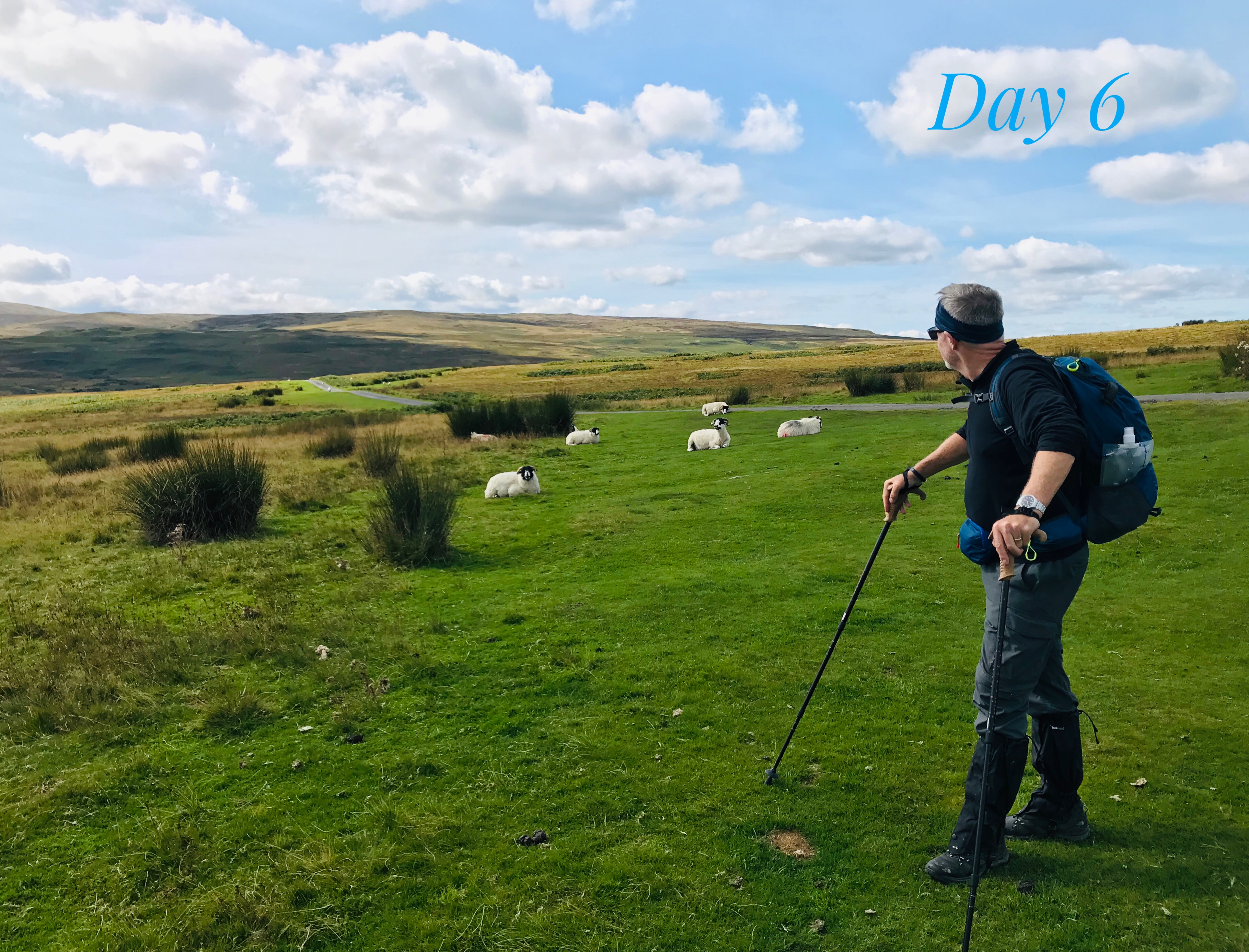
Day 6 – Glenridding to Bampton Grange
Art’s Impressions
With the uncertain weather and the forecast of high winds in the pass we decided to go our own way today, and boy are we glad we did, it was our best day so far. Our Canadian friends recommended a route, which we took their advice and caught the Ullswater Steamer up the lake from Glenridding to Pooley Bridge. When we arrived at the boat on the morning we realized this was the same boat we sailed on with Sarah and Annie five years ago on our last family visit to the UK, so a little nostalgic.

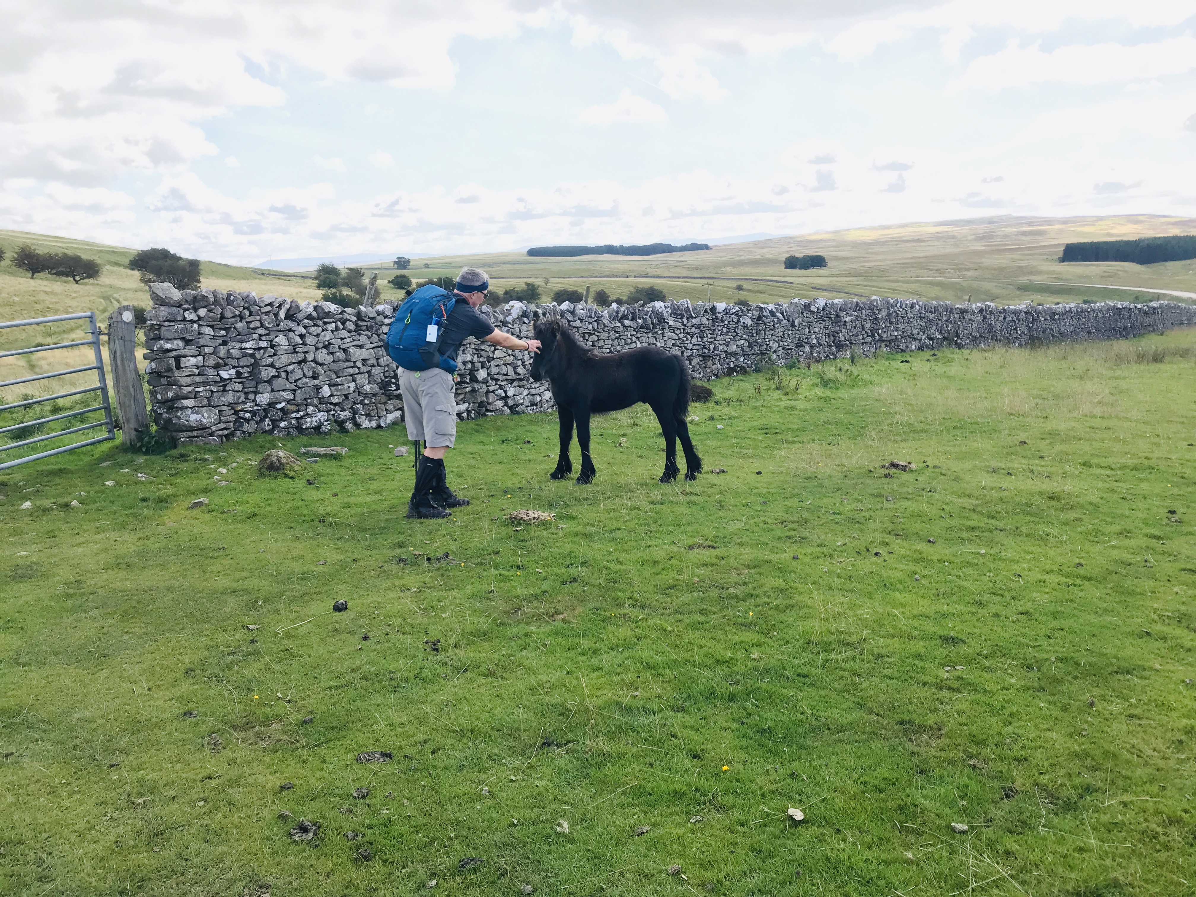
The weather turned out to be absolutely beautiful and after arriving at Pooley Bridge we began our 12 KM walk over the Askham Fells to Bampton Grange, our stop form the night. We both remarked that this was what we had envisioned when we booked this trip, gorgeous fields lined by stone fences the bleating of sheep to mark our way. I can safely say, the number of shades of green in England are countless. We arrived invigorated and enthused once again about this adventure.

Heidi’s Impressions
Today we decided to cheat just a bit and avoid a nasty and precarious peak. The Canadian sisters told us the route they took last year: The Ullswater Steamer boat to the end of the Ullswater Lake and then an 11 km walk from the pier at Pooley Bridge to Bampton Grange (which was our scheduled end point). We were very glad we did. This day was what we had envisioned the Coast to Coast walk to be: beautiful weather and gorgeous undulating hills crisscrossed with stone walls and everywhere dotted with sheep. Fantastic! Along the way we saw an ancient stone circle, burial mounds and Roman roads. We stayed at a lovely Inn, met up with 3 other C2C walker couples in the Pub, great conversation and Steak and Ale Pie for dinner. All is good in my world!


Day 7 – Bampton Grange to Orton
Art’s Impressions
Another great weather day and it began with a walk through a graveyard to start the day, which continued through once green field after another along a winding river and through one stone fence after another. We met up and walked with a couple of cool Aussie’s we had met the night before and we visited the ruins of an Abby from the 1200’s. We have met many very cool people along the way and really looked forward to re-crossing paths over the days.


We used our GPS on the phone and the Map.me program to locate the grave of Robin Hood and grabbed some shot for posterity’s sake. We arrived in Orton to sample treats from the local chocolate factory, yum yum.

Heidi’s Impressions
We have officially left the Lake District and are now into The Dales. Lovely sunny day again today and our path started through a churchyard, through green pastures and over stiles in stone walls. We walked along the route with 2 other couples, chatting occasionally and within visual contact at all times. One couple from Australia and the other from London: they walked much of the way together as the couple from London played aloud the radio play of “The Cricket” the whole route (national championship match, or some such thing, between Australia and England) so they were all interested. Art and I were not at all interested and I found the sports commentary rather unwelcome in such quiet surroundings! Super nice people though and we look forward to walking ‘close-ish’ with them tomorrow!
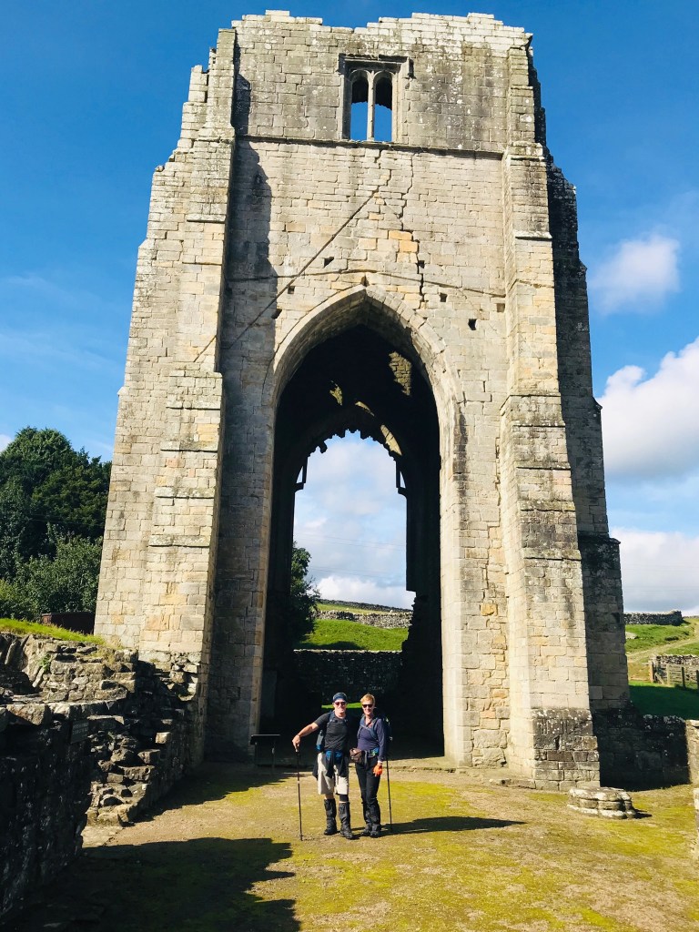
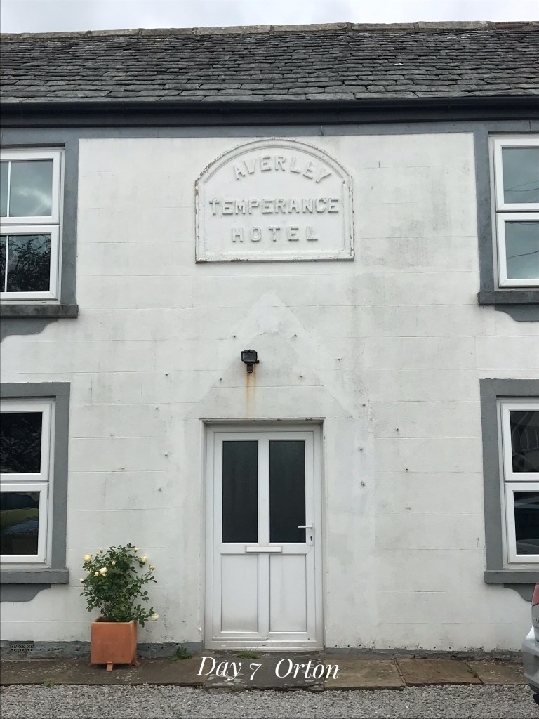
Along the way passed an Abbey from the 11th century and ate our lunch in the centre of another ancient stone circle. But the highlight of the day for me was Robin Hood’s grave! Not marked at all but our map book and GPS pointed it out. No plaque either but someone had laid a red and yellow quiver (from bow and arrow) on the grave rocks. Very cool experience for us! After 7 hours underway, we wandered into Ortin around 4:00, stopped at the chocolate factory (!), had a look at the church from the 1200’s, the stocks on the village green (the public place of punishment), a Temperance Hotel (located temptingly across the street from the establishment “licensed to sell intoxicating liquors for consumption off the premises”).

Day 8 and 9 – Orton to Kirkby Stephen
Art’s Impressions
Even though we awoke to a drizzle we were still in high spirits as we set out. The Dales are a completely different landscape from the lake district and we really enjoyed the rolling hills and public footpaths we wandered on. Knowing we had a rest day ahead we had an extra spring in our steps knowing we would be reunited with our new friends the Canadian Sisters over an Indian meal. It did not disappoint, and best of all, every one of the friends we had made on the first leg of our trip that we lost on the last rest stop were all there after tasking a rest day here.


It was heart-warming to witness five groups of complete strangers a week ago meeting with embraces like long lost friends. The comradery on this trail is inspiring, clearly over the shared experiences, both good and bad. We also lucked out to have chosen our rest date to coincide with the Tour of Britain bike race coming through town, the whole town was abuzz with excitement and the shops houses and churches were all adorned with bicycle paraphernalia and British flags everywhere. The actual race took no more than 30-45 seconds to come through town, but it was worth it in the eyes of all the locals.
Heidi’s Impressions
Woke up to another day of rain but despite this had a great day walking the Yorkshire Dales National Park. This area is very barren of trees and one can see for miles around from the hill tops. There is a lot of lovely purple heather amongst the green grass as well as waist high fern fields. The public foot paths pass through farmers’ fields: many gates to go through and stiles to climb over rock walls. And many different breeds of sheep. And all sporting different coloured dye spots and patterns on the backs (called “smit” marks) so that the farmer can tell at a distance which sheep belong to him or his neighbour.
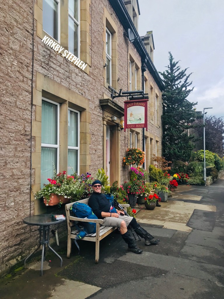
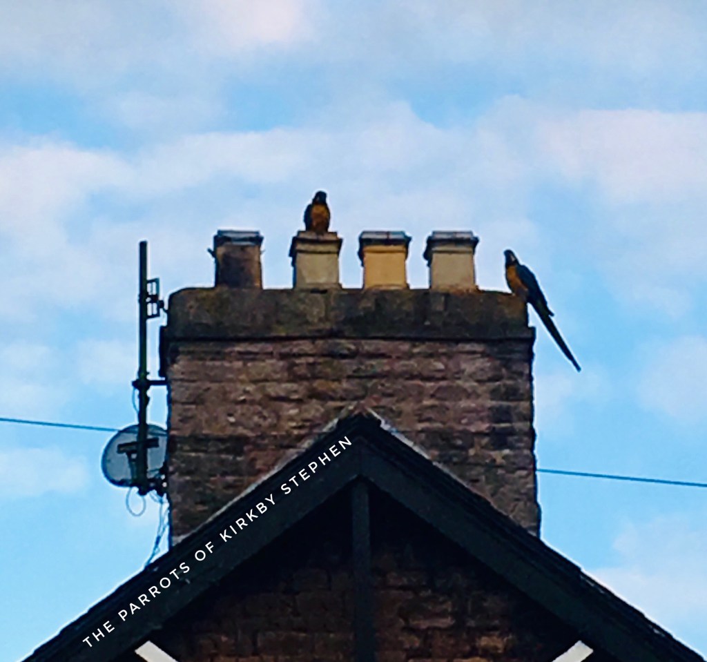
We arrived to Kirkby Stephens in early afternoon to tea and scones with clotted cream and jam served up by Carol, the owner of the Jolly Farmer and met up with our Canadian Sisters for a fantastic dinner at the local curry house. On our way to dinner we were surprised to see and hear 2 colourful macaw parrots flying back and forth along the rooftops! We found out that a local gentleman had had a large collection of exotic birds which were released every day to fly the countryside and village to return each night. As parrots can live for up to 100 years and because he was a wealthy man, when he died, he set aside an endowment for the birds to be taken care of, as long as they lived. Over the years as the birds have died, the sightings have become less and less so we were very lucky to have seen likely the last 2 remaining!
The next day was a rest day for us here which we spent wandering the quaint village and seeing the local sights. It also just happened to be the day that the Tour of Britain raced through. The Main Street of town was decorated with banners and flags and there were entertainers, music and festivities for hours beforehand. Then there were 30 seconds where the cyclists sped by and then it was done!
Day 10 – Kirkby Stephens to Keld (12 Miles)
Art’s Impressions
After a nice rest day in Kirkby Stephens we were raring to go but had a few misgivings due to the reports of treacherous bogs on the moors beyond 9 Standards Rigg. This range called the Pennines is referred to as the backbone of Britain as the river flow east or west depending on the side of the ridge you on. At the top of the ridge there are 9 large cairns that can be seen from all directions and have a mythical quality as nobody truly knows who put them there or why. They stand like sentinels guarding the moors and have the feel of Stonehenge or Easter Island. Historically this region is where the industrial revolution began with the lead mining in the area.
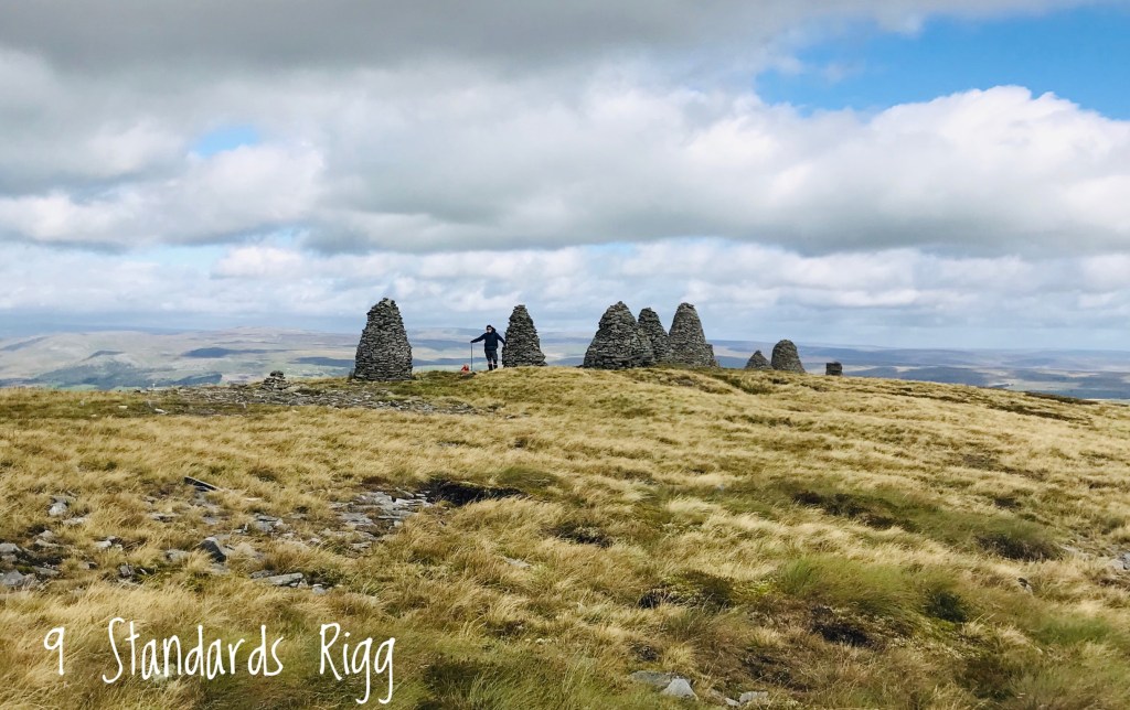
Because our weather was so good, we decided to go the high route and test ourselves across the moors and the legendary and ominous bogs. These bogs are everywhere and without the help of the pylons showing the direction we should go we would surely have gotten lost. There are two types of bogs, black bogs which are overly wet peat (created by decaying heather) that turns into quicksand and the green moss bogs which camouflage deeps water holes cause by limestone erosion. Either one can quickly soak you to your waist or worse, so you need to poke your walking sticks in before every step to ensure a dry passage. A one-kilometre crossing of the moors took us 2 hours and with the help of a tiny British lady named Judith we learned the tricks and what routes to look for.

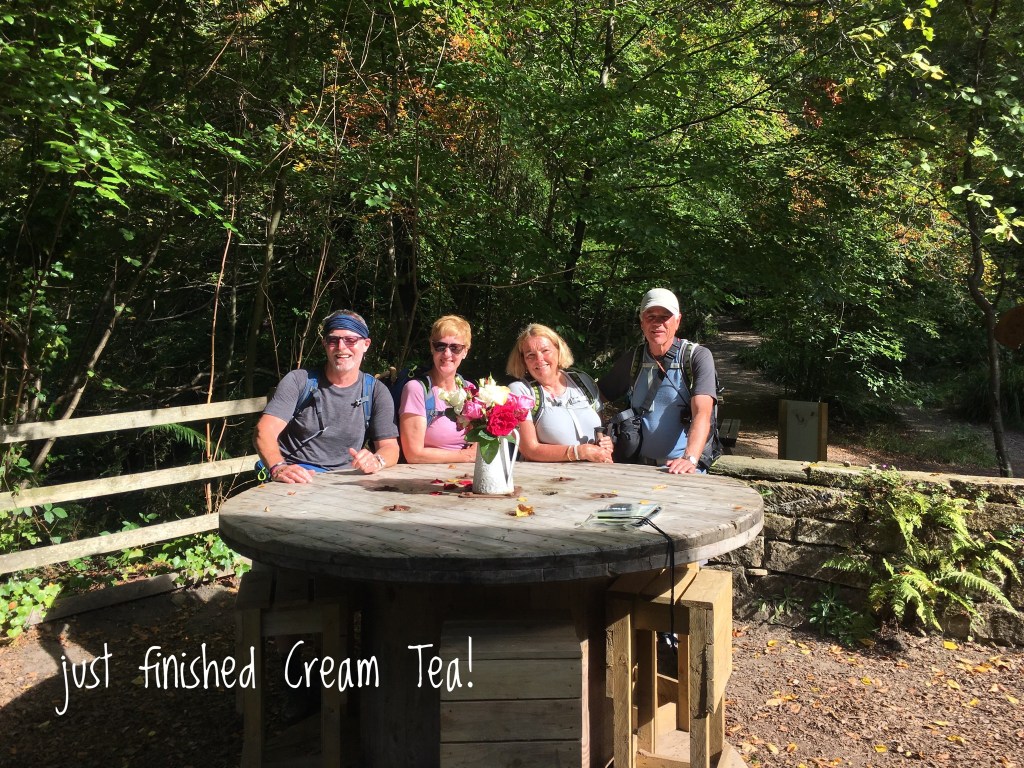
Long reed-like grass was laid flat and used to step across and watching for the tufted tips of grass served as footsteps though the mind field. Amazingly we crossed without sinking or even getting soaked. We treated ourselves to cream tea, (Scones with clotted cream and jam served with coffee of tea) at a farmhouse just the other side of the moors. The lady who runs this little tea shop is famous in Britain as the Yorkshire Shepherdess and has written books and had a BBC series made about her.

Heidi’s Impressions
Leaving today we were feeling pretty cocky. We knew that the trek to and over Nine Standards Rigg was going to be great, especially if the weather was good and we felt fully prepared for “THE BOGS, bwahahaha” (said in a very scary Vincent Price voice). Even the locals warned us of this: miles of unstable ground on the top of the plateau where people have become mired up to their chests and needed mountain rescue to be extricated. We learned about what not to step on: bright green sphagnum moss floats on top of deep holes, black heather is really hiding many inches of peat bog and then of course there is plain old mud. Armed with this knowledge and 100 £ of waterproof socks (heard at the pub that night “and then I sold the 2 Canadians waterproof socks! Drinks on me!”) out we set.

The 9 Standards are 9 ancient rock formations (each about 10 feet tall) set in a line at the top of the ridge. The origin of the nine “stone men” or columnar cairns on the summit, is a mystery, but they are very ancient and are marked on 18th century maps. One theory is that they were constructed by the Roman army to look like troops from a distance. Very cool to experience these figures coming in and out of the mist. Then on to the bogs themselves.
Our guidebook mentioned that these were very tricky and that many hikers had been injured and many more had lost their boots and dignity as well as the will to carry on! We were lucky and did not become stuck nor even deeply mired but this was only through careful avoidance by stepping very gingerly for literally miles from grass clump to grass clump and detouring repeatedly around huge muddy pits. We even saw what we think was a sheep stuck up to its belly in the bog. Well we know it was a sheep but were not sure if it was stuck and we could not get closer to do anything about it. So, we took a picture against recognizable backdrops and emailed it to our contact back in the previous town who forwarded it on to the farmers who run their sheep on that mount for them to go check it out! Hope it was all right. Anyways our ankles and knees were unbelievably sore that night from walking on that terrain (and everybody else in the pub that night were similarly hobbling!). BUT I am happy to report that our feet were dry!!!

Also found out that “Cream Tea” is not cream in your tea but rather tea with scones with clotted cream and jam. So now these signs in some tiny village have so much more meaning and are that much harder to avoid! We stayed overnight in the town of Keld. Very small town of perhaps 10 dark grey stone houses. Must be very depressing in winter. Also weirdly lots of roadkill. Had seen none until now and then in the space of a mile there were 4 bunnies, 3 peasants and 2 Mrs. Tiggywinkles (hedgehogs for those of you not Beatrix Potter fans). I think because of the stone walls along these narrow roads
Day 11 – Keld to Grinton (11 Miles)
Art’s Impressions
Heidi and I have been feeling stronger and stronger as the walk progresses and this day was particularly encouraging as we walked out of Keld and down onto the valley of the River Swale where we would spend the morning winding our way through farmers fields crossing what seemed like hundreds of gates or stiles (steps built over or between stone walls or over fences) staying just steps ahead of the weather. We were treated to beautiful rainbows over our shoulders, which was both good and bad. Good from an Instagram perspective but was the harbinger of our afternoon weather. We popped into the little town of Muker with our newfound friend Chris from Manchester for cream tea on the recommendation of the Canadian sisters who are a day ahead and bush whacking the trail for us.

Our tea stop gave the weather a chance to catch up, so we walked in various stages of rain for the next while, beginning with a fine mist and escalating to a steady drizzle by mid-day. We bypassed the tea shop and pub for a dry lunch in the next town in favour of pressing on to avoid the worst weather catching us. Well that is a decision we would like to revisit as the trail left the river and we climbed steadily uphill for an hour until we were on the edge of the moors on a ridge overlooking the river valley.
On a good day the view would have made the climb worth it, but the weather had really whipped up with high winds and driving rain blowing uphill on our downhill side. It was blowing so hard you could hardly maintain a straight course and Heidi and I were laughing hysterically feeling more like kites than walkers. Heidi had changed into her poncho, which is black, and I looked sideways at her and the poncho was blown straight up off her back acting like a sail. I couldn’t help thinking Captain Jack Sparrow would have loved sailing the Black Pearl that day. We realized the real trail was actually 75 meters higher up and once we popped up there the wind became less a factor and we navigated the remainder of the moors without incident and wound down from the moors back to the riverside and the last part of our day was in sunshine. We were actually dry when we reached our inn for the night.
Each of our inns have been charming, although some a little tired, but always staffed by warm wonderful hosts serving excellent grub for dinner and massive big English breakfast to start our days.
Heidi’s Impressions
Leaving Keld it was, of course, drizzling but we were soon fortified by a lovely cream tea in the tiny town of Muker along the way! The drizzle was almost continuous, only interrupted by torrential sideways rain and wind. At one point we were walking high up on an open moor and I honestly thought we should hit the ground so as not to blown off. Luckily the wind was at our backs. We considered going back down and taking the river route but for the fact that we could not have walked head on into that wind: it literally would have been impossible. When we came to cross-roads and encountered some other walkers who had taken an even higher route, this lovely tiny English woman smiled and said, “yes but wasn’t it all very much fun?”

The area is beautiful, and we walked along the Swale River for most of the way. Sheep is still the primary crop here, but we have started to see some cattle and dairy herds now too. The houses and barns are almost all plain dark stone and many abandoned years ago. These surrounding hills are scarred with evidence of mining, primarily lead. What once brought prosperity to the area, almost brought its ruin. Many people had left their traditions of farming to work in the mines and when many mines were bankrupted in the early 19th century due to cheaper imports from the Americas, many of these towns almost died along with the industry. Most of these now rely greatly on the tourist trade and the establishment of the Yorkshire Dales National Park should help bring many more crazy walkers here. Notably most of the C2C’ers we have met have not been English and many of the locals regard us with awe and amusement!
Spent the night in an Inn in Grinton, noteworthy for its amazing food but also its comfortable shabbiness. There were towels on the floor in the dining room sopping up a flood from the ceiling, downstairs washrooms with stone walls complete with moss and lichen in the corners, hallways and stairs that were spongy, crooked and broken. And of course, the pub was filled with locals and their dogs, and a lot of talk of Brexit!
Day 12 – Grinton to Richmond (12 Miles)
Art’s Impressions
It’s nice to report we had an uneventful day with excellent weather and kind track with gentle ups and downs. Even with the ideal conditions Heidi and I both suffer on the downhill and especially if it’s paved roads, which is what we had the end our day.

The good news was we had a rest day in Richmond to look forward to and dinner with our dear friends the Canadian sisters. Thanks to them we also expanded our circle of friends by two, meeting Richard and Michael. This walk is amazing at how easy it is to meet great people and make friends. These two chaps were fellow walkers during the girls’ C2C trip last year and they conspired to surprise them this year and share a day walk with them. We feel lucky to be associated with so many cool, interesting and nice folks on this walk.

Heidi’s Impressions
Today we walked from Grinton to Richmond in the beautiful sunshine. The scene was so bucolic as to be almost boring. One green field after another separated by dry stone walls (‘dry’ meaning not held together with mortar) creating checkerboard patterns on the gentle hills. Met and walked with many of our new walker friends and arrived at our destination mid-afternoon. A slight hiccup had us go to a guest house only to be told by the proprietress that she had had a back injury and cancelled all bookings at least a week ago! She called our tour group and found the new location for us and we walked back to a guest house we had passed 30 minutes ago (after 13 or so miles another 1 added on is annoying!).

Anyhow, somehow the email that our tour co sent informing us of this change did not reach us. But we were welcomed with hearty and loud greetings by the Russian owner at the Pinfold House (they are a new guest house not yet on the approved list of the walking companies) so she, Tanya, and her partner, David, were very eager to make a good impression, which they did. She called me “darling” and embraced me to her substantial bosom when we checked out! We met our friends, the Canadian Sisters, and 2 of their friends from their C2C last year for dinner and exchanged tales and laughter. We were very sad to say goodbye as we will not see them again on this walk (they will always be one day ahead of us and will have left Robin Hoods Bay on the morning that we arrive).
Day 13 – Rest Day in Richmond
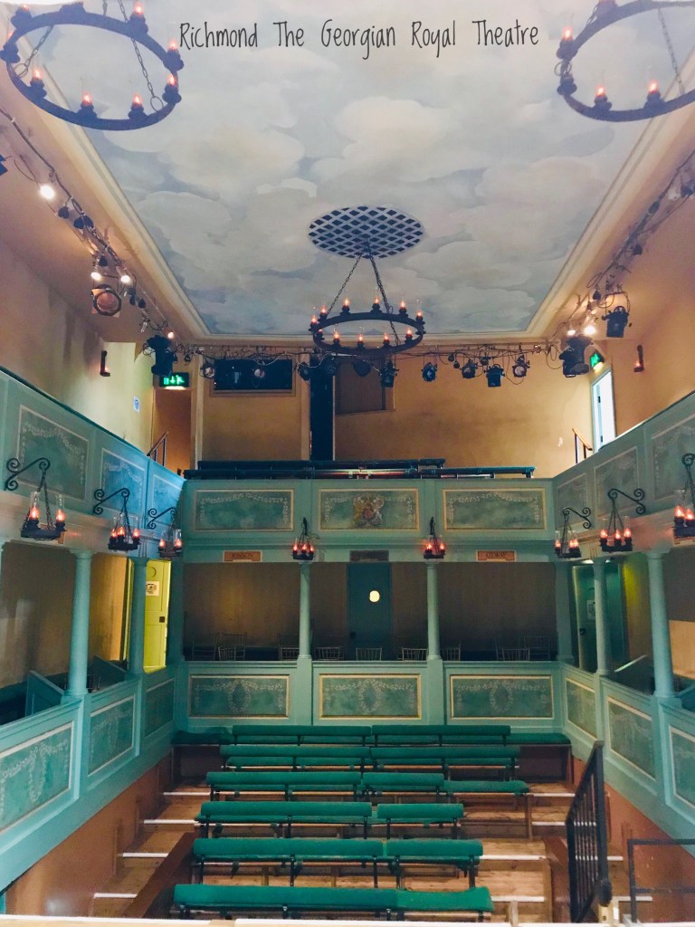
Richmond was a rest day for us. This is a charming town, with a market square, many shops, a castle and an impressive Abbey. Very interesting also is The Georgian Theatre Royal. Built in 1788, it is the UK’s oldest working theatre. It still has a Royal Box, but Camilla and Charles must give them advance notice if they plan to attend (as they sell their seats!). Dame Judy Dench is the theatre’s president. We were taken on a one hour guided tour by a very knowledgeable and enthusiastic volunteer guide who told us the history of the building and its original owners and explained all the workings of the old theatre. Very neat.
C2C Day 14 – Richmond to Danby Wisk (13.5 Miles)
Art’s Impressions
Wainwright himself “lost little love for this tepid agricultural tract claiming it the low point of his project in more than just elevation”. The least pretty of the days so far it started well along the pretty path aside the River Swale, but we soon started to hear the motorway in the distance which was the harbinger of things to come. In fairness we are in a season where the fields are barren and ploughed under, but we didn’t find much enjoyment in the vistas. To make matters worse we had to walk for nearly 3.5 miles on roads, not the best thing for Heidi’s and my knees. This make it sound terrible, it wasn’t. It just wasn’t as spectacular as the previous days in the heart of the dales. We had a great dinner with our new Kiwi friends Tom and Janet and I had an amazing plate of bangers and mash to warm my insides.

Heidi’s Impressions
Leaving Richmond was a bit of a drag as I had misplaced my poles somewhere on the day we walked into Richmond and they could not be found. We left the guest house at 9:00 and walked to the various places they might have been left to no avail. And as it was Sunday, Mountain Warehouse did not open until 10:30. So we hung around the square, had to talk to the crazy man who sat down next to us on the bench, went for coffee, talked to the Taxi drivers who were standing around chatting about the Saturday night antics from the night before and the second the door was opened, dashed into the store, bought poles and practically jogged out of town!
The day was hard going only because for a change they were many miles of bone jarring road walking. The scenery was nice, and the weather was constantly changing from light rain (surprise!) to sun so jackets and rain pants on and off repeatedly. At 4:30 we hobbled into the White Swan Inn at Danby Wisk on an ibuprofen induced haze. We had heard tales from other walkers of the bartender: a reputation as a cranky man not amused with fancy drink orders. But he poured me the fullest glass of wine ever – I had to sip it off the top before I picked it up off that bar! He must like Canadians!
Day 15 – Danby Wisk to Ingleby Cross (9 Miles)
Art’s Impressions
We rose to a beautiful day and set out at 9:00 after a big tasty English breakfast. This stage was very flat and wound through one farmer’s field after another and through gates and over stiles using Public Footpaths. In England and Wales, a public footpath is a path on which the public have a legally protected right to travel on foot and in some areas public footpaths form a dense network of short paths. It is probable that most footpaths in the countryside are hundreds of years old. They cross private property over fences, new and old.

The stone fences have narrow openings that you can barely fit your butt and rucksack through and the stiles over newer fences have you stepping up and flinging your leg over to steps on the other side. It would be impossible for this walk to take place if the access to these public footpaths weren’t protected by law as 98% of this route follows these footpaths. The day was beautiful and short, and we rested at the end of the walk in a memorial park by the pub, because it wasn’t open yet. Heidi worried people might be offended by us snoozing by the cenotaph, but I told her I had it covered: if anyone complained I would say it was appropriate as we were DEAD tired.
Heidi’s Impressions
The route from Danby Wiske to Ingleby Cross was fairly boring actually. That stage of the C2C runs mainly alongside or through fields which at this time of year have been harvested and/or ploughed under which made it exceedingly difficult to walk across and also sometimes impossible to find the path. On green pastures one can see the path or at least the pressed down grass of previous walkers but on hard pack dirt and field stubble it was much more difficult. Regardless we did not get lost and spent much of our picture taking energies on the various different types of stiles we had to use to navigate over the farm fences and walls. The most strenuous aspect of today’s walk was a mad dash across 4 lines of highway!

Day 16 – 18 – Ingleby Cross to Grosmont (35 Miles)
Art’s Impressions
Following Heidi’s lead I am combining the next three days through the moors as a single entry as the scenery and landscape remained relatively unchanged: endless heather at the top of the moors and green valleys in between. The walking on the tops was flat and we found the time there meditative. The ups and downs were what surprised both of us. We were told by a talkative chap in St Bees that the moors were flat and boring. We now disagree with both of this assertions.


We experienced the steepest climbs on the route during this stage and worse, the steepest descents. We were thanking our lucky stars it wasn’t raining as the steep stone stairs that dominated this stage would have been treacherous and for some terrifying. Our friends the Canadian sisters had warned Heidi about climbing the Wain Stones so she took a lower route but my new friend Irene and I picked our way up through the sheer face following little paths in between and scrambling through some sections. It was worth it, the views allowed us to see in all directions, including views of our destination, the North Sea.
The moors were not without interest: we were on the lookout for the only poisonous snake in the UK, the black adder, which lives in the heather as well as sheep ticks, which carry lime disease. Luckily it was past tick season and we saw no adders but I did jump a few times when spotting black shoe laces on the trail.


We had varied experience with accommodations along the way, from a top notch B&B with a stunning view of the valley to staying in the equivalent of a garden shed where we froze our butts off. I can’t even imagine how the campers did it: we have encountered numerous walkers along the way who are wild camping as they walk the route and it was getting very cold during the nights now. In Grosmont we felt great upon arrival so paid a visit to the steam rail yards where repairs are undertaken on the fleet of remaining coal fired steam engines. I left with mixed feeling, nostalgic and fascinated by them, (what boy doesn’t live a train), but troubled that coal is still burned to move these beasts around.

Heidi’s Impressions
Leaving our Inn at Ingleby Cross we climbed steadily up and into the North York Moors National Park. But first we had to negotiate the path through the vicious local pheasants! The moors are widely used for pheasant hunting, the stocks of which are raised in large forested enclosures: these are large tracts of land fenced like a wildlife reserve and containing over 10 000 birds. Once the birds reach juvenile age they can figure out how to leave the enclosure and then are found wandering the roads and pastures. They are not afraid of humans as the presence of people usually means someone is bringing food. Consequently the young males run along in front or alongside and make it difficult to pass. Everyone we spoke to had had to defend themselves with their sticks from an overly aggressive young cock!


The track rose steadily higher until we cleared the trees and reached the plateaus of The North Yorkshire Moors National Park: the heather stretched for miles as far as the eye could see. Not a tree to see (having been decimated for ship building, first by the Romans and then the Victorians). This moorland is used for the grazing of sheep and the hunting of pheasant and the enjoyment of walkers. Unfortunately we missed the flowering of the heather by about 3 weeks but to see it all in purple would be truly amazing. The walking was pleasant when it was on the flat plateaus but we climbed up and down to 5 such plateaus that day: a lot of steep ascents and descents. The weather was great though and the winds were favourable enough for the hang gliders to be flying almost directly with us (the wind currents come up from the valley to literally lift the hang gliders right into the air from the edge of the plateaus). It was amazing to be walking along the edge and hear a flapping noise and see a huge colourful glider drifting by!

This stage of the C2C through the North York Moors National Park was 3 days. We had lovely weather and great company and amazing views and great fun. At one point we could see across the whole distance that we had travelled: from the distant pikes of the Lake District to the left to the faint blue of our destination, the North Sea, on the right. But despite all this fantastic scenery there is not much more to describe each day for you and so I will skip forward to our last day!
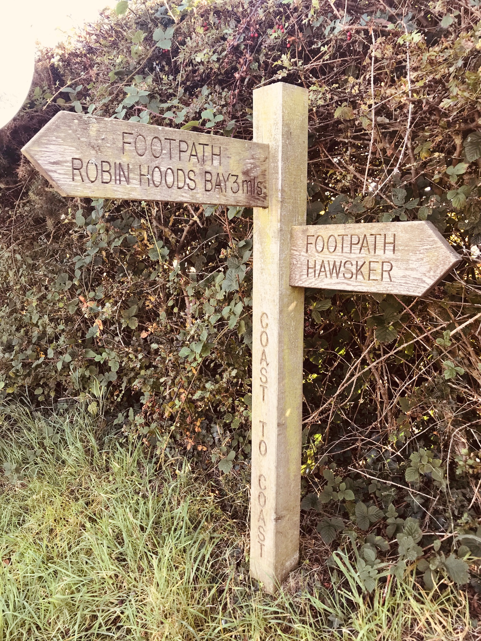
Day 19 – Grosmont to Robin Hoods Bay (15 Miles)
Art’s Impressions
We left Grosmont excited to know this was our last day on the C2C and blessed with ideal weather. All the various people we walked with decided we each wanted to walk this last bit the way we started, alone in some cases and with our partners in other. The climb out of Grosmont was epic, two miles straight uphill with 33% grade. We sure did appreciate the trail training we had done over the past weeks and with our trusty poles to aid us we made the ascent without too much trouble. This brought us back to the gentleness of the moors and heather and we took our time, lingering on this last day almost not wanting it to end, (I said almost).


We were tantalized along the way with views of the North Sea, and as we came closer, clear views of Whitby Abby on the top of the cliffs. We visited the Abby (the inspiration for Bram Stoker’s Dracula’s Castle) with the girls six years earlier so old memories flooded back for me. We finally reached the cliffs hugging the east coast and this served as the final runway into Robin Hood’s Bay and the completion of our journey. We both dipped our toes in the North Sea and deposited our rocks to fulfil the pledge C2C walkers make in St Bees. We then joined the fellow walkers we had shared the trail with to celebrate our accomplishments and swap stories of the last day over beers.
It amazes me the number of close relationships we made on our 16 day crossing and to have a chance to share this with them was emotional special experience we won’t soon forget. If you don’t believe we did it, go check out our names in the register in the pub at the bottom of that seemingly endless hill.
Heidi’s Impressions
Today we woke up in the lovely village of Grosmont. This town is most popular now with steam train aficionados. There is a museum and works yard and apparently the steam engine that pulled Hogwarts Express in the Harry Potter movies was from there. After yet another FEB (Full English Breakfast), we tied our shoes and grabbed our poles and set out for our last day of walking Wainwright’s Coast to Coast Trail. It was not going to let us off easy as the route out of town immediately had us hoofing it up a 33 % grade with no let-up for 2 miles! This would have left us completely “knackered” a mere 2 weeks ago but both of us have become noticeably stronger in that time. And I should hope so. I am certain no pounds have been lost due to those FEBs, pub food and my new favourite drink, Guinness and Black (a stout with a shot of black current syrup. Really) but our muscles and stamina have increased with every one of those 192 miles!

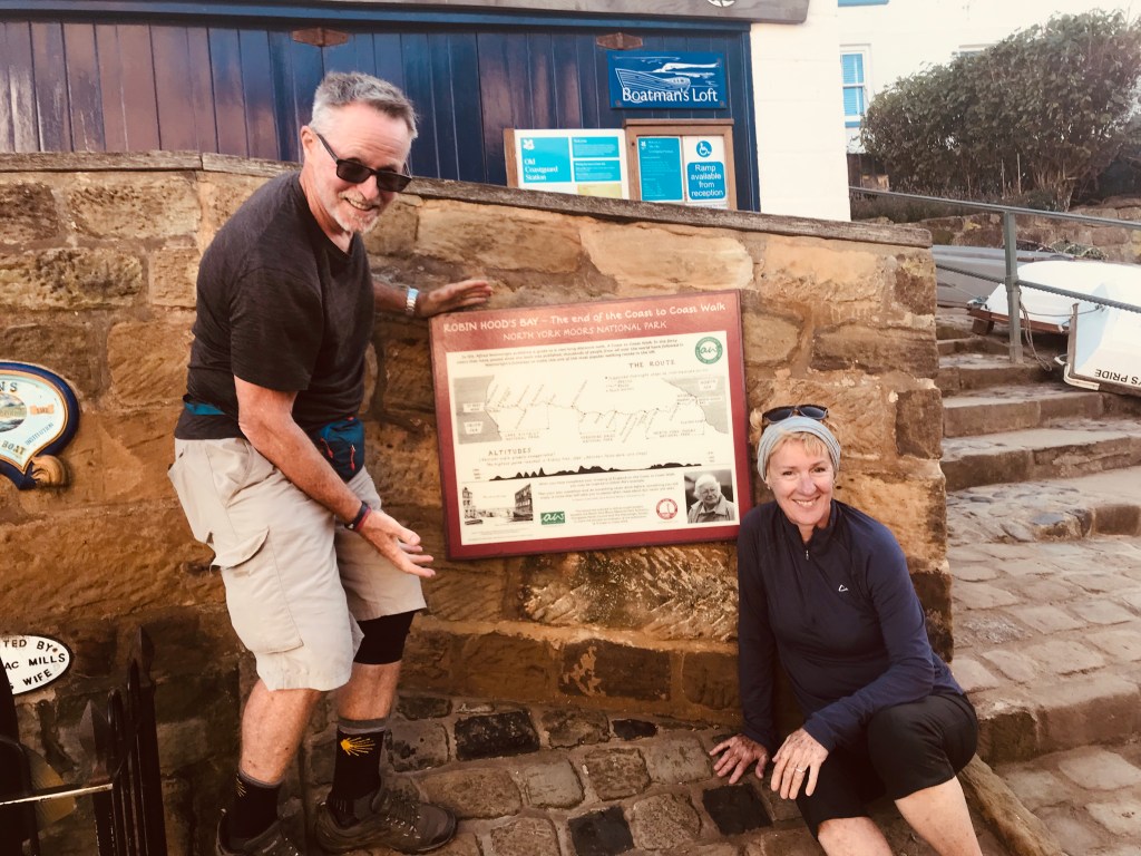
The long incline took us again into the last of the heather moors and then back down into the lovely green pastures as we approached the cliffs edging the North Sea. The final 2 miles were along these gorgeous cliffs: a perfect bookend to the coastal cliffs that climbed out of St. Bees on our first day leaving the west coast. We cheered unabashedly at our first glimpse of the surf crashing into Robin Hoods Bay and the town nestled around it and then had to suffer one last nasty descent down the unbelievably steep road of the town to the shore side. We dipped our boots into the sea and tossed the pebble that we had collected in St Bees and that accompanied us on this incredible journey. But most of all we cheer for and are cheered by friends we have picked up along the way: these connections we will remember long after the pain in our joints fades!


What!! When did you do this amazing cross country trek? Last summer? You two have really impressed me, having accomplished El Camino and this C2C trek! Really enjoyed reading your narratives and looking at the photos. Thanks for sharing! Greg
LikeLike
Sorry for the confusion. I am reposting the blog sections I needed to move from the old platform when the last provider decommissioned their site. We did this in 2019.
LikeLike
What an amazing experience. Thank you for sharing it.
LikeLike
Dear Heidi &Y Art What an adventure!!! It’s wonderful to hear from you and see that you are out there doing exciting things. Loved the travelogue and the pictures. What’s next?
I’m starting to get anxious as the days count down to leaving for Mexico…all while still getting organized for Christmas. I’m heading to Melaque via PV on January 3. Jan & Feb at the playa and then possibly some travelling around for March. After reading your journey, I definitely need to up the ante and get back into adventure spirit. Enough of this “hanging out at the beach” routine; time for something more daring!
I’ll miss your presence at the beach; I so enjoyed your company. What will you be doing to get out of winter in Vancouver?
Thanks for putting me on your list… keep the stories coming. All the VERY best for 2024.
Big hugs Maria
>
LikeLike
Hello my dear I was just thinking about you yesterday. We are having lunch with Pricilla, Glen and Rod today, all ex Melaquites. Sorry for the confusion, I was moving this post from the old blog site to the new, we actually did the C2C in 2019. I have been lazy and am only now getting around to finishing the cross continental North America posting and will then tackle our Camino de Santiago pilgrimage that we completed in October. Have fun in Mexico, you never know we may bump into each other down there is we cant stand the rain here.
LikeLike